Cart
You have no items in your shopping cart
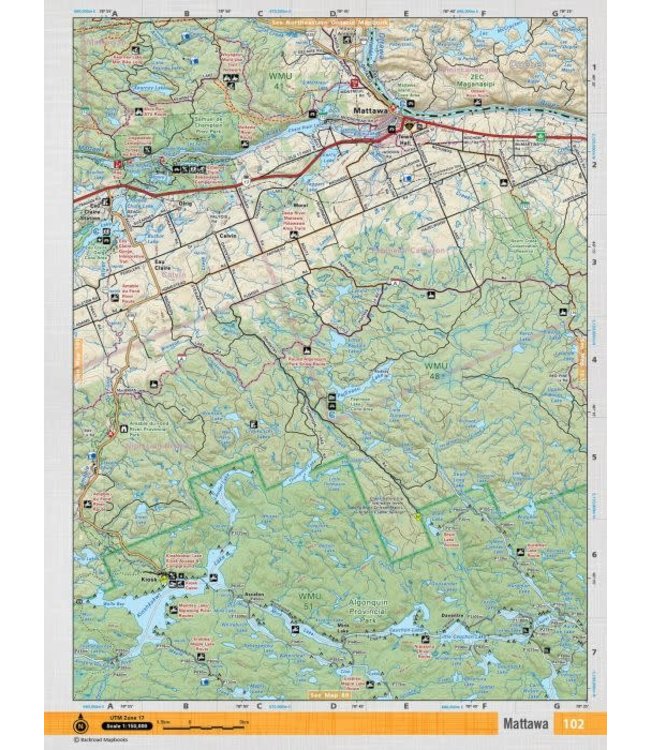
This recreation topographic map for Mattawa highlights all the logging/resource roads, hunting areas, fishing lakes & streams, campsites, paddling routes for canoeing and kayaking, wildlife viewing areas, multi-use trails for hiking, biking, horsebac Read more..
This recreation topographic map for Mattawa highlights all the logging/resource roads, hunting areas, fishing lakes & streams, campsites, paddling routes for canoeing and kayaking, wildlife viewing areas, multi-use trails for hiking, biking, horseback riding, cross-country skiing and snowshoeing, motorized trails for ATVing and snowmobiling & more. Covering 1,090 km2 (420 mi2)in total, this 1:50,000 scale map is available in digital or trackable PDF format to use on several 3rd Party apps including Avenza, Locus Maps and Topo Maps+. New features include enhanced Crown land data, countless new roads and trails and a wealth of recreational Points of Interest. Included on this map are Mattawa, Algonquin, Samuel de Champlain, Provincial, Amable du Fond River, Calvin, Olrig and more!
This map also covers the following Wildlife Management Units: WMU 59.
Mattawa - Cottage Country Ontario comes in both Print and Digital Versions. The Digital or mobile TOPO version is a calibrated PDF map that allows tracking, adding waypoints, zooming in and out and other GPS features. These maps can be used on 3rd party apps on your smartphone or tablet including Avenza, Locus Maps and Topo Maps+. You will need to download the app and find our maps in their store. We offer the entire mapbook map options (all maps in that mapbook) on all apps, while the individual maps are also available on Avenza.
0 stars based on 0 reviews
Add your review